Opzioni
Utilizzare i dati di Google Earth
- Utilizzare i dati di Google Earth
-
Utilizzare i dati di Google Earth
da strawberryfield » 3 ott 2011, 22:46
Scopo di questa serie di post è quello di introdurre la possibilità di sfruttare i dati forniti da Google Earth per creare layout in Rail3D.
Con Google Earth si possono piazzare dei segnaposto e creare dei tracciati quindi questi dati possono essere salvati in un file .kml (oppure nella sua versione compressa .kmz).
Il file così ottenuto è in XML e quindi analizzabile con apposite librerie disponibili per ogni sistema operativo; in Windows è presente la libreria di Microsoft necessaria anche al funzionamento di Internet Explorer.
Estrarre quindi i dati dal file di Google è una operazione semplice.
Google Earth ci restituisce i punti con coordinate geografiche basate su latitudine e longitudine espresse in gradi, mentre Rail3D mappa i suoi layout su un piano con coordinate cartesiane espresse in metri ed origine nel punto in basso a sinistra.
Si pone quindi il problema di "schiacciare" la sfera terrestre su un piano: è lo stesso problema di costruire una carta geografica.
Per fare ciò si utilizzano delle proiezioni che proiettano i punti della superficie terrestre sul piano: ci sono svariati tipi di proiezioni, ognuna con i suoi pregi e difetti, ma è ben noto che la proiezione perfetta non esiste. Un nutrito campionario di proiezioni si può trovare in http://www.geometrie.tuwien.ac.at/karto/index.html#14, mentre in http://web.unife.it/progetti/matematicainsieme/matcart/tipiprz.htm c'è una analisi dei vari tipi di proiezione.
Il digitizer di Rail3D utilizza, come d'altronde anche l'Istituto Geografico Militare per le sue tavolette o il "Portale Cartografico Nazionale" http://www.pcn.minambiente.it, la "Proieziene Traversa di Mercatore".
Questo tipo di proiezione spezzetta la superficie sferica in striscie lungo i meridiani e proietta l'immagine su un cilindro tangente al meridiano centrale della fascia.
Il sistema cartografico UTM considera la Terra divisa in 60 fusi, ampi 6° di longitudine ciascuno, numerati da 1 a 60 a partire dall'antimeridiano di Greenwich (cioè la linea di cambiamento di data in mezzo all'oceano Pacifico) e procedendo verso est.
L'Italia occupa i fusi 32, 33 e una piccola parte del 34.
Per maggiori dettagli potete consultare http://www.sapere.it/sapere/strumenti/studiafacile/scienza/La-Terra/La-rappresentazione-cartografica-della-superficie-terrestre/Approfondimenti/Proiezione-trasversa-di-Mercatore-e-Sistema-Utm.html nonchè alcune mie note per procurarsi i dati DEM del Portale Cartografico http://www.trainsimhobby.com/forum/topic.asp?TOPIC_ID=7505.
Esistono delle formule che permettono di trasformare questi tipi di coordinate e se ne trova una esauriente descrizione in http://www.matematicamente.it/staticfiles/approfondimenti/astronomia/CoordinateGaussiane.pdf
A questo punto abbiamo gli elementi per convertire le coordinate geografiche in piane, ma ancora non basta perchè lo spazio piano possibile in Rail3D è limitato a circa 600x600 km mentre le nostre coordinate possono arrivare a qualche migliaio di km.
Per oggi ho spaventato abbastanza, e quindi mi fermo qui. -
da strawberryfield » 5 ott 2011, 22:57
Proseguiamo la nostra analisi dell'utilizzo dei dati di Google Earth per Rail3D
Innanzitutto cerchiamo di capire cosa si può importare in Rail3D
1) Labels, semplici etichette posizionate in un punto (x,y). La stessa cosa in MSTS sono ad esempio i marker.
Per ottenere le labels il manuale ci dice che dobbiamo predisporre un foglio di calcolo (Excel, OpenOffice Calc o quello che preferite) con quattro colonne, nella prima va sempre il testo "TEXT", nella seconda la coordinata X, nella terza la Y ed infine nella quarta il testo dell'etichetta.
Si copiano le celle e si incollano nell'editor di Rail3D e le labels magicamente appaiono.
2) Impostare punti terreno: esattamente come il punto precedente, ma cambia il testo fisso che diventa "TERRAIN" e l'ultima colonna che riporta l'altitudine in metri.
Purtroppo Google Earth nella sua versione gratuita non restituisce l'altezza dei punti e quindi non è usabile direttamente. (bisognerebbe leggere il dato DEM da altre fonti, affronterò la problematica in futuro)
3) Inserire nodi, tratti di binario e scambi.
La sintassi in questo caso è leggermente più complessa, ma il vero problema consiste nel fatto che è richiesta l'altezza del nodo e quindi ricadiamo nel caso precedente. Ciò che devo investigare è cosa succede impostando la proprietà "set node at terrain level" e lasciando a 0 l'altezza nei dati.
Un esempio di posa binari con questo sistema la potete trovare in
Detto ciò vediamo un esempio: alcuni punti della pista dell'ippodromo di Cesena
Codice: Seleziona tutto
   <?xml version="1.0" encoding="UTF-8"?>

   <kml xmlns="http://www.opengis.net/kml/2.2" xmlns:gx="http://www.google.com/kml/ext/2.2" xmlns:kml="http://www.opengis.net/kml/2.2" xmlns:atom="http://www.w3.org/2005/Atom">

   <Document>

      <name>Ippodromo.kml</name>

      <StyleMap id="msn_ylw-pushpin">

         <Pair>

            <key>normal</key>

            <styleUrl>#sn_ylw-pushpin</styleUrl>

         </Pair>

         <Pair>

            <key>highlight</key>

            <styleUrl>#sh_ylw-pushpin</styleUrl>

         </Pair>

      </StyleMap>

      <Style id="sn_ylw-pushpin">

         <IconStyle>

            <scale>1.1</scale>

            <Icon>

               <href>http://maps.google.com/mapfiles/kml/pushpin/ylw-pushpin.png</href>

            </Icon>

            <hotSpot x="20" y="2" xunits="pixels" yunits="pixels"/>

         </IconStyle>

      </Style>

      <StyleMap id="msn_ylw-pushpin0">

         <Pair>

            <key>normal</key>

            <styleUrl>#sn_ylw-pushpin2</styleUrl>

         </Pair>

         <Pair>

            <key>highlight</key>

            <styleUrl>#sh_ylw-pushpin1</styleUrl>

         </Pair>

      </StyleMap>

      <Style id="sn_ylw-pushpin0">

         <IconStyle>

            <scale>1.1</scale>

            <Icon>

               <href>http://maps.google.com/mapfiles/kml/pushpin/ylw-pushpin.png</href>

            </Icon>

            <hotSpot x="20" y="2" xunits="pixels" yunits="pixels"/>

         </IconStyle>

      </Style>

      <StyleMap id="msn_ylw-pushpin1">

         <Pair>

            <key>normal</key>

            <styleUrl>#sn_ylw-pushpin1</styleUrl>

         </Pair>

         <Pair>

            <key>highlight</key>

            <styleUrl>#sh_ylw-pushpin0</styleUrl>

         </Pair>

      </StyleMap>

      <Style id="sn_ylw-pushpin1">

         <IconStyle>

            <scale>1.1</scale>

            <Icon>

               <href>http://maps.google.com/mapfiles/kml/pushpin/ylw-pushpin.png</href>

            </Icon>

            <hotSpot x="20" y="2" xunits="pixels" yunits="pixels"/>

         </IconStyle>

      </Style>

      <Style id="sh_ylw-pushpin">

         <IconStyle>

            <scale>1.3</scale>

            <Icon>

               <href>http://maps.google.com/mapfiles/kml/pushpin/ylw-pushpin.png</href>

            </Icon>

            <hotSpot x="20" y="2" xunits="pixels" yunits="pixels"/>

         </IconStyle>

      </Style>

      <Style id="sh_ylw-pushpin0">

         <IconStyle>

            <scale>1.3</scale>

            <Icon>

               <href>http://maps.google.com/mapfiles/kml/pushpin/ylw-pushpin.png</href>

            </Icon>

            <hotSpot x="20" y="2" xunits="pixels" yunits="pixels"/>

         </IconStyle>

      </Style>

      <Style id="sh_ylw-pushpin1">

         <IconStyle>

            <scale>1.3</scale>

            <Icon>

               <href>http://maps.google.com/mapfiles/kml/pushpin/ylw-pushpin.png</href>

            </Icon>

            <hotSpot x="20" y="2" xunits="pixels" yunits="pixels"/>

         </IconStyle>

      </Style>

      <Style id="sh_ylw-pushpin2">

         <IconStyle>

            <scale>1.3</scale>

            <Icon>

               <href>http://maps.google.com/mapfiles/kml/pushpin/ylw-pushpin.png</href>

            </Icon>

            <hotSpot x="20" y="2" xunits="pixels" yunits="pixels"/>

         </IconStyle>

      </Style>

      <StyleMap id="msn_ylw-pushpin2">

         <Pair>

            <key>normal</key>

            <styleUrl>#sn_ylw-pushpin0</styleUrl>

         </Pair>

         <Pair>

            <key>highlight</key>

            <styleUrl>#sh_ylw-pushpin2</styleUrl>

         </Pair>

      </StyleMap>

      <Style id="sn_ylw-pushpin2">

         <IconStyle>

            <scale>1.1</scale>

            <Icon>

               <href>http://maps.google.com/mapfiles/kml/pushpin/ylw-pushpin.png</href>

            </Icon>

            <hotSpot x="20" y="2" xunits="pixels" yunits="pixels"/>

         </IconStyle>

      </Style>

      <Folder>

         <name>Ippodromo</name>

         <open>1</open>

         <description>Ippodromo di Cesena</description>

         <Style>

            <ListStyle>

               <listItemType>check</listItemType>

               <bgColor>00ffffff</bgColor>

               <maxSnippetLines>2</maxSnippetLines>

            </ListStyle>

         </Style>

         <Placemark>

            <name>Arrivo</name>

            <LookAt>

               <longitude>12.23210010083588</longitude>

               <latitude>44.14433663138394</latitude>

               <altitude>0</altitude>

               <heading>0.003276226120089498</heading>

               <tilt>0.04373104733540818</tilt>

               <range>244.7399320508613</range>

               <altitudeMode>relativeToGround</altitudeMode>

               <gx:altitudeMode>relativeToSeaFloor</gx:altitudeMode>

            </LookAt>

            <styleUrl>#msn_ylw-pushpin</styleUrl>

            <Point>

               <altitudeMode>clampToGround</altitudeMode>

               <gx:altitudeMode>clampToSeaFloor</gx:altitudeMode>

               <coordinates>12.23207537755476,44.14382792157764,0</coordinates>

            </Point>

         </Placemark>

         <Placemark>

            <name>Arrivo lato tribuna</name>

            <LookAt>

               <longitude>12.23213902287877</longitude>

               <latitude>44.1443163185978</latitude>

               <altitude>0</altitude>

               <heading>2.710809129418501e-005</heading>

               <tilt>0</tilt>

               <range>244.6536947408126</range>

               <altitudeMode>relativeToGround</altitudeMode>

               <gx:altitudeMode>relativeToSeaFloor</gx:altitudeMode>

            </LookAt>

            <styleUrl>#msn_ylw-pushpin1</styleUrl>

            <Point>

               <altitudeMode>clampToGround</altitudeMode>

               <gx:altitudeMode>clampToSeaFloor</gx:altitudeMode>

               <coordinates>12.23199815503766,44.14361377111013,0</coordinates>

            </Point>

         </Placemark>

         <Placemark>

            <name>per calcolo inclinazione</name>

            <LookAt>

               <longitude>12.23155379868458</longitude>

               <latitude>44.14397818208246</latitude>

               <altitude>0</altitude>

               <heading>14.05818530502537</heading>

               <tilt>0</tilt>

               <range>402.7257460440399</range>

               <altitudeMode>relativeToGround</altitudeMode>

               <gx:altitudeMode>relativeToSeaFloor</gx:altitudeMode>

            </LookAt>

            <styleUrl>#msn_ylw-pushpin2</styleUrl>

            <Point>

               <altitudeMode>clampToGround</altitudeMode>

               <gx:altitudeMode>clampToSeaFloor</gx:altitudeMode>

               <coordinates>12.2326307364384,44.14503408034735,0</coordinates>

            </Point>

         </Placemark>

         <Placemark>

            <name>Hippotram</name>

            <styleUrl>#msn_ylw-pushpin0</styleUrl>

            <LineString>

               <tessellate>1</tessellate>

               <coordinates>

                  12.23019968047102,44.1436990646726,0 12.22982723982488,44.14371451997106,0 12.22963125156578,44.14390015883947,0 12.2293344934247,44.14428380914369,0 12.2291687267439,44.14455846684811,0 12.22911579780884,44.144786432916,0 12.22912769073768,44.14493674615868,0 12.22920409962574,44.14514485027289,0 12.22934181817229,44.14527804320389,0 12.2295494402961,44.14545510763151,0 12.22971557136716,44.14554231761719,0 12.22993692210792,44.14560537872954,0 12.23024585350736,44.145690011482,0 12.23051108527029,44.14579843617741,0 12.23074374858207,44.1458609604246,0 12.23096670638319,44.14592153603664,0 12.23108580206972,44.14592153706389,0 12.23125903516813,44.14585905216096,0 12.23145383660227,44.14583574519224,0 12.23169198032639,44.14579701139562,0 12.23174672555664,44.14560357076742,0 12.23193607332347,44.14553335312404,0 12.23256728989408,44.14539276740531,0 12.23278065674339,44.1453117518474,0 12.23311024627987,44.14521065612707,0 12.23332162685084,44.14510967496832,0 12.23353705651073,44.14495022375198,0 12.23368397699932,44.14475166886797,0 12.2337229642892,44.14458509890444,0 12.23390458901544,44.14386971743652,0 12.23389798785112,44.1437424580886,0 12.23384941766567,44.1436688803758,0 12.23373608814992,44.14359917667694,0 12.23305072205924,44.14338619880129,0 12.23247379909847,44.14320921182975,0 12.23202528486844,44.14310634472822,0 12.23190676351169,44.14310651184951,0 12.2318745601584,44.14314486232821,0 12.2317560785995,44.14314102446708,0 12.23150296630336,44.14316789058185,0 12.23063015710304,44.14333390592292,0 12.23052750967561,44.14340332211442,0 12.23051638225097,44.14348821686089,0 12.23052684981566,44.14356544303134,0 12.23048884155054,44.14362725695248,0 12.23039691605805,44.14367750144516,0 12.23028895992643,44.14368909780256,0

               </coordinates>

            </LineString>

         </Placemark>

      </Folder>

   </Document>

   </kml>
Copiare questo codice e salvarlo come [b]ippodromo.kml[/b]
Ci servirà una liberia per la trasformazione delle coordinate come questa:
Codice: Seleziona tutto
   /* NDSFutility.js JavaScript functions for NDSF coordinate conversion utility */


   PI = 3.1415927;

   RADIANS = 57.2957795;       /* degrees/radian */


   RADIUS = 6378137.0;

   FLATTENING = 0.00335281068; /* GRS80 or WGS84 */

   K_NOT = 0.9996;     /* UTM scale factor */

   DEGREES_TO_RADIANS = 0.01745329252;

   FALSE_EASTING = 500000.0;

   FALSE_NORTHING = 10000000.0;


   /*----------------------------------------------------------

   #   The following functions are modified from the origin

   #   C functions created by Louis Whitcomb 19 Jun 2001

    ---------------------------------------------------------*/


   function utm_zone(slat, slon)

   {

      with(Math)

      {

         /* determine the zone for the given longitude

            with 6 deg wide longitudinal strips */


         var zlon= slon + 180; /* set the lon from 0-360 */


        for (var i=1; i<=60; i++)

         {

            if ( zlon >= (i-1)*6 & zlon < i*6)

            {

               break;

            }

         }

         var zone=i;


         /*  modify the zone number for special areas */

         if ( slat >=72 & (slon >=0 & slon <=36))

         {

             if (slon < 9.0)

             {

                 zone= 31;

             }

             else if ( slon  >= 9.0 & slon < 21)

             {

                 zone= 33;

             }

             else if ( slon >= 21.0 & slon < 33)

             {

                 zone= 35;

             }

             else if ( slon  >= 33.0 & slon < 42)

             {

                zone= 37;

             }

         }

         if ( (slat >=56 & slat < 64) & (slon >=3 & slon < 12))

         {

             zone= 32;  /* extent to west ward for 3deg more */

         }

         return (zone);

       }

       return true;

   }


   /*-------------------------------------------------*/


   function geo_utm(lat, lon, zone)

   {

      with(Math)

      {

         /* first compute the necessary geodetic parameters and constants */


         lambda_not = ((-180.0 + zone*6.0) -3.0)/RADIANS ;

         e_squared = 2.0 * FLATTENING - FLATTENING*FLATTENING;

         e_fourth = e_squared * e_squared;

         e_sixth = e_fourth * e_squared;

         e_prime_sq = e_squared/(1.0 - e_squared);

         sin_phi = sin(lat);

         tan_phi = tan(lat);

         cos_phi = cos(lat);

         N = RADIUS/sqrt(1.0 - e_squared*sin_phi*sin_phi);

         T = tan_phi*tan_phi;

         C = e_prime_sq*cos_phi*cos_phi;

         M = RADIUS*((1.0 - e_squared*0.25 -0.046875*e_fourth  -0.01953125*e_sixth)*lat-

            (0.375*e_squared + 0.09375*e_fourth +

                0.043945313*e_sixth)*sin(2.0*lat) +

            (0.05859375*e_fourth + 0.043945313*e_sixth)*sin(4.0*lat) -

            (0.011393229 * e_sixth)*sin(6.0*lat));

         A = (lon - lambda_not)*cos_phi;

         A_sq = A*A;

         A_fourth =  A_sq*A_sq;


         /* now go ahead and compute X and Y */


         x_utm = K_NOT*N*(A + (1.0 - T + C)*A_sq*A/6.0 +

            (5.0 - 18.0*T + T*T + 72.0*C -

             58.0*e_prime_sq)*A_fourth*A/120.0);


         /* note:  specific to UTM, vice general trasverse mercator.

            since the origin is at the equator, M0, the M at phi_0,

            always equals zero, and I won't compute it   */


          y_utm = K_NOT*(M + N*tan_phi*(A_sq/2.0 +

                (5.0 - T + 9.0*C + 4.0*C*C)*A_fourth/24.0 +

                (61.0 - 58.0*T + T*T + 600.0*C -

                 330.0*e_prime_sq)*A_fourth*A_sq/720.0));


          /* now correct for false easting and northing */


          if( lat < 0)

          {

             y_utm +=10000000.0;

          }

          x_utm +=500000;


          /* adds Java function returns */

          var utmxy={};

          utmxy={x:x_utm,y:y_utm};

          return(utmxy);

       }

       return true;

   }
Copiare questo codice e salvarlo come [b]NDSFlib.js[/b]
Infine il programma di trasformazione
Codice: Seleziona tutto
   <!--

   Google Earth .kml to Rail3D labels converter

   (c) copyright 2011 Roberto Ceccarelli

   -->


   <job>

   <runtime>

   <named name="kml" helpstring="File kml da convertire" required="true" type="string" />

   <named name="lat0" helpstring="Latitudine punto base" required="true" type="string" />

   <named name="lon0" helpstring="Longitudine punto base" required="true" type="string" />

   <named name="utmzone" helpstring="Fuso UTM in cui effettuare la conversione (se omesso viene calcolato sulla longitudine del punto base)" required="false" type="string" />

   <named name="xoffset" helpstring="Offset orizzontale in metri del punto base" required="false" type="string" />

   <named name="yoffset" helpstring="Offset verticale in metri del punto base" required="false" type="string" />

   </runtime>


   <script language="JScript" src="NDSFlib.js">

   </script>


   <script language="JScript">

   // check main arguments

   if( !WScript.Arguments.Named.Exists("kml")

     || !WScript.Arguments.Named.Exists("lat0")

     || !WScript.Arguments.Named.Exists("lon0") ) {

       WScript.Arguments.ShowUsage();

       WScript.Quit();

   }

   var ll = {

     olat: WScript.Arguments.Named("lat0")*1,

     olon: WScript.Arguments.Named("lon0")*1,

     xoffset: 0,

     yoffset: 0

   }


   // detect utm zone

   if( WScript.Arguments.Named.Exists("utmzone") ) {

     ll.utmzone = WScript.Arguments.Named("utmzone")*1;

   } else {

     ll.utmzone = utm_zone(ll.olat, ll.olon);

   }


   // optional offsets

   if( WScript.Arguments.Named.Exists("xoffset") ) {

     ll.xoffset = WScript.Arguments.Named("xoffset")*1;

   }

   if( WScript.Arguments.Named.Exists("yoffset") ) {

     ll.yoffset = WScript.Arguments.Named("yoffset")*1;

   }


   // convert origin point to utm

   var xy = geo_utm(ll.olat/RADIANS, ll.olon/RADIANS, ll.utmzone);

   ll.x0 = xy.x;

   ll.y0 = xy.y;


   // parsing kml file

   var kml = new ActiveXObject("msxml2.domdocument");

   kml.async = false;

   kml.load(WScript.Arguments.Named("kml") + ".kml");

   var marklist = kml.getElementsByTagName("Placemark");

   var marker, coord;

   var re = /^(d+.d+),(d+.d+).*/;

   for(var i=0; i<marklist.length; i++) {

     marker = marklist.item(i);

     coord = marker.getElementsByTagName("coordinates").item(0).text;

     ll.slon = coord.replace(re, "$1")*1;

     ll.slat = coord.replace(re, "$2")*1;

     xy = geo_utm(ll.slat/RADIANS, ll.slon/RADIANS, ll.utmzone);

     WScript.StdOut.WriteLine(""TEXT"t"+ Math.floor(xy.x - ll.x0 + ll.xoffset) +"t"+ Math.floor(xy.y - ll.y0 + ll.yoffset) +"t"" + marker.getElementsByTagName("name").item(0).text +""" );

   }

   </script>

   </job>
Copiare questo codice e salvarlo come [b]kml2label.wsf[/b]
Da lanciare, da linea di comando, con
Codice: Seleziona tutto
   cscript kml2label.wsf //Nologo ^

     /kml:ippodromo ^

     /lat0:44.14382792157764 /lon0:12.23207537755476 ^

     /xoffset:20000 /yoffset:20000 ^

     >ippodromo_lbl.csv
Ne otterremo il file ippodromo_lbl.csv
Codice: Seleziona tutto
   "TEXT"   20000   20000   "Arrivo"

   "TEXT"   19993   19976   "Arrivo lato tribuna"

   "TEXT"   20048   20132   "per calcolo inclinazione"

   "TEXT"   19849   19990   "Hippotram"
Da aprire con il vostro foglio elettronico preferito, copiare le celle e incollarle in rail3D
Ecco il risultato:
[b]Immagine:[/b] 180,32 KB
Per il momento consideratelo una magia, nei prossimi post cercherò di svelare il "trucco" in modo che possiate applicarlo ai vostri layout. -
da timetable57 » 6 ott 2011, 1:32
Grande Roberto, aspettavo questo tool.
Mi riservo di leggere con calma il tutto. Potresti però per piacere tradurlo in un programmino come quell'altro? Così provo e poi pubblico. Sottoponilo anche a Mark.
Grazie -
da strawberryfield » 6 ott 2011, 9:51
timetable57 ha scritto:
Grande Roberto, aspettavo questo tool.
Mi riservo di leggere con calma il tutto. Potresti però per piacere tradurlo in un programmino come quell'altro? Così provo e poi pubblico. Sottoponilo anche a Mark.
Grazie
ne manca ancora un pezzettino...
Dopo averlo completato non mancherò di farvelo avere
ciao -
da strawberryfield » 8 ott 2011, 14:07
Ho chiesto conferma a Mark circa la possibilità di ignorare il parametro elevazione nella posa dei binari da file e mi ha confermato che la cosa allo stato attuale non è possibile anche se non sarebbe affatto impossibile con un semplice ritocco al codice.
Ho comunque deciso di intraprendere un'altra strada: creare un programma che aggiunga ai files .kml estratti da Google Earth il dato di elvazione recuperandolo da una tabella di DEM.
Ho già modificato il programma della labels in modo che generi volendo anche i punti terreno (era una assoluta banalità): così facendo potremo generare terreno e nodi alla stessa identica altezza evitando possibili "scollamenti".
Il programma è pronto, devo solo collaudarlo un attimino e fare delle istruzioni comprensibili.
A presto -
da timetable57 » 8 ott 2011, 14:58
Bravo Roberto,
Ho letto questa mattina lo scambio di missive tra te e Mark.
Penso che un programma simile potrebbe soppiantare il difficilmente comprensibile "Digitizer".
Forse, ma probabilmente dico una sciocchezza, occorrerà implementare un qualche script che legga le DEM. Per R3D la lettura DEM, allo stato attuale, comporta diversi passaggi non semplici.
P.S. Quasi pronto il pack E424 (tre livree). Son riuscito a capire faticosamente il settaggio dei pantografi. Con le bielle della loco a vapore, per assurdo, è stato molto più semplice. Metterò, appena pronto, tutto nero su bianco in area tutorial.
E comunque grazie -
da strawberryfield » 10 ott 2011, 22:53
Il programma è finito, genera labels e punti terreno (ma che non avendo i dati di elevazione sono tutti a 0, comunque saranno per uso futuro)
Ho inserito anche una intefaccia grafica per quelli che si spaventano davanti alla linea di comando.
Completo le istruzioni e poi mando tutto per la pubblicazione
Intanto ho perso tempo a fare questo:

-
da timetable57 » 10 ott 2011, 23:46
Sarà sempre meglio del "famigerato "Digitizer"
Mark ha caricato molti dei 3D nel database. Gli avevo detto di caricare tutto ma non sò cosa combina.
Son riuscito finalmente a fargli rimettere a posto il database.
Per il tuo programma bisognerebbe vedere se si potessero implementare in qualche modo le DEM.
Comunque, la cosa che mi fà piacere, è che noi Italiani stiam facendo una bella figura. -
da strawberryfield » 11 ott 2011, 10:20
timetable57 ha scritto:
Per il tuo programma bisognerebbe vedere se si potessero implementare in qualche modo le DEM.
Arriverà anche quello, basta sostituire lo zero in fondo alle coordinate con il dato prelevato da una tabella DEM; ho già la struttura della tabella dei DEM e mi manca solo da trovare un buon algoritmo di interpolazione dei valori -
da timetable57 » 11 ott 2011, 11:26
Ciao Roberto,
son molto fiducioso nelle tue risorse.
Il "digitizer" di R3D è un programma buono in partenza e nelle intenzioni ma obsoleto e di difficile utilizzo. ltretutto si adatta meglioalle ferrovie inglesi, tedesche o svizzere per le quali era nato.
Penso che Mark sarà molto soffisfatto di queste novità -
da strawberryfield » 20 ott 2011, 11:22
Da alcuni scambi di messaggi con Michele, che ha il non facile compito di testare il mio programma, ho notato che può essere utile spiegare come creare in Google Earth questi benedetti placemark e soprattutto come esportarli.
Aperto Google Earth sulla sinistra c'è una finestra "Luoghi", cliccate destro sul primo elemento contenuto, scegliete "Aggiungi" e poi "Cartella".
Si creerà un nuovo nodo nell'albero, rinominatelo e lasciatelo selezionato.
A Questo punto si possono piazzare nella mappa i "pirullini" gialli, vedrete che per ogni segnaposto piazzato si aprirà un nuovo nodo sotto la cartella creata in precedenza.
Se vi sbagliate potete sempre trascinare i segnaposti nell'albero sotto alla cartella giusta.
Una volta terminato il piazzamento cliccate destro sulla cartella e scegliete "salva con nome", cambiate il tipo di file da .kmz a .kml e salvate.
Passate in forno (ehm, al programma) e troverete sul layout le indicazioni dei vostri "pirullini"
roberto
p.s. si possono creare anche dei percorsi, che il programma gestisce, ma questo un'altra volta
-
da timetable57 » 21 ott 2011, 1:00
Ciao Roberto, son convintissimo che dal tuo tool uscirà qualcosa che potrà fare una piccola rivoluzione in R3d
Io però l'ho provato e qualcosa non ho capito. Cosa intendi per copiare il contenuto del file .csv nella cartella principale di rail3D? -
da strawberryfield » 21 ott 2011, 9:42
timetable57 ha scritto:
Io però l'ho provato e qualcosa non ho capito. Cosa intendi per copiare il contenuto del file .csv nella cartella principale di rail3D?
Non nella cartella, nella finestra principale di Rail3D
cfr. le istruzioni alla voce using spreadsheet for digitizing -
da strawberryfield » 22 ott 2011, 13:28
[b]Novità:[/b]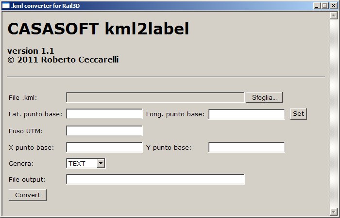 38,79 KB
Per rendere più comprensibile l'uso dello strumento ho cambiato la denominazione dei campi (e aggiornerò di conseguenza la documentazione)
Inoltre ho inserito quel bottone "Set" che permetterà di usare un placemark come punto base senza dover ricopiare a mano le coordinate.
Michele e Guido avete un MP.
roberto -
da timetable57 » 22 ott 2011, 15:35
Ottimo.
Avrei un suggerimento se la cosa è fattibile. Come tute le cose pubblicate qui finiscono anche in Inghilterra. E possibile prevedere un qualche cosa che possa eventualmente sfruttare i punti elevazione di google sketchup Pro?.
Magari qualcuno degli Amici Inglesi lo usa..
Solo per ragioni di completezza e in attesa di poter usare le DEM.
Ottimo lavoro come sempre Roberto
Grazie